
Deposition to clarify the assertion that the listing of sites E4b and E4d as being within ‘Existing Employment Areas’ is as a result of an historical civil wrong. Our contention is that the two sites should consequently be removed from the classification. While they are ‘relatively’ insignificant and beyond justifiable need for employment purposes they are irreplaceable for local natural environmental value. It goes some way to explaining how the unusual designation of the nearby roads affected development pressure and traffic growth and why further expansion is unwelcome.
The proposed sites are either side of a location which used to be occupied by a former Royal Naval Victualling Depot.
By 1980 the Depot was virtually dormant, and it was sold off in the early 1980’s leaving a site that was, for some time, the cause of some vexatious planning matters involving FBC, HCC, this society and a good deal of distress to local residents.
Three particular ‘happenstances’ have fogged the issue of development ambitions and permissions:
- The siting of the old Depot in a countryside location.
- The curious designation of the nearby roads
- The advent of two industrial estates close by and the construction of the M27 motorway
Firstly, the Depot was virtually an island in an area long-designated Coast and Countryside in successive Local Plans so that although outline planning permission had been built into the sale for some development as a reasonable concession to the historical land use, it also gave recognition to environmental needs by prescribing that the remaining half of the site should be returned to natural land.
The stipulation that the size of the footprint should not exceed that of the old site was robustly defended by FBC, but it was doggedly attacked by the new owners through various unacceptable ideas e.g. extension vertically with mezzanine floors etc.
The main problem which rapidly emerged, however, was the destructive effect that the passage of heavy lorries, cranes, diggers and other heavy machinery was having on the (well recognised) inadequate road structure and its verges together with the damage to quality of life nearby.
The subsequent application was for a waste recycling centre. It was strongly opposed by FBC who offered alternative locations and our local petition returned 760 signatures of people opposed to it. As with all such facilities, however, the final decision rested with HCC – which was adverse, unfortunately, prompting calls for a judicial review. The excessive plans of the then owners, which included widening Pinks Hill were scaled down and the depot’s activities were reduced to an operationally acceptable level. Today the Transfer Station could be considered a reasonable neighbour for the most part but its contribution to the heavy use of the road network which half surrounds the village ensures that the issue remains sensitive, even if dormant. Regrettably it is also the case that the site footprint, so carefully prescribed originally, has now virtually doubled.
Secondly there is a curiosity about the local roads which few people are probably aware of today. Pinks Hill road and that part of Military Road which connects with Drift Road are remnants of the old military road system which ran along the top of Portsdown Hill and ended up by the Delme Roundabout and into Wallington Village respectively.
When they ceased to be required by the MOD (probably sometime in the 1960’s) they were, we understand, given over to the Borough but could not be adopted as Highways. They were instead designated as Public Open Space. This fact had a lot of bearing in the saving of half of Pinks Hill woodland from a large scale housing development in the 1980’s when planning permission had been achieved but the necessary highway access (usually a formality) was effectively blocked through the technicality. Private road advisory signs are sited at various places.
When the M27 went through in the early 70’s Pinks Hill road was to have been closed, however the proposal caused widespread alarm – both from the business occupants of Fort Wallington (then a newish Industrial Estate) whose only decent access was that road and from Wallington residents who realised that the only other route for lorries if it had to be closed would be through the narrow roads of the village. The feeder road for the forthcoming Fareham Industrial Park (originally called the Link Road - now named Wallington Way) was yet to be built and the traffic generated in nearby Broadcut by a newly relocated FBC Depot already gave a foretaste of things to come.
The Department of Transport was reluctant to leave an access in place because it was (and maybe still is) their stated policy not to allow a road like this to impinge on a motorway slip road. But they allowed it as a concession until such time as the promised new roads were built - i.e. Standard Way and the Link road. Any major upgrade, even now, might be problematical to the Highways Agency.
Forty years on and the use of the road has grown significantly, especially so because Wallington has such a high density of industrial premises within its boundaries and immediate vicinity. Hence there is a lot of sensitivity about the risk of more development, both housing and industrial, which the continued existence of this road increases. The road from the Industrial Park up to Fort Wallington is steeply graded with a bend near these proposed new employment sites and it suffers fast-moving traffic going to and from the motorway approach road via Pinks Hill. It is now an established, convenient short-cut, commuter route.
A question mark must hang over the legality of setting aside the original conditions that presumably applied when the roads were transferred to FBC. Similarly, there might be a concern about whether the hard-won restrictions on the use of Pinks Hill by heavy vehicles travelling to or from the Waste Transfer Station could still be enforced and/or extended to more general (increased) traffic use.
Conclusion:
There can be few areas in the Borough so interwoven with industrial activity as Wallington, both past and present, and it has been assimilated fairly peacefully. Above us we have Fort Wallington, the SUEZ recycling depot and nearby offices, Fareham Industrial Park encircles our western flank and the FBC Depot plus a retail park are across the river from us. Our long history (probably longer than that of Fareham) embraced the workshop of the town, notably the Tannery and the Brewery.
Despite this the village has retained a character and appeal that is well known. Together with a long-established pattern of care by its residents it has managed this partly because of the retention of cherished fragments of rural landscape at its fringes, like narrow lanes where horses are still not uncommon. The two sites now threatened (E4b and E4d) are typical small fragments.
This is a crowded corner of what we now know from a BBC report is a disproportionately crowded part of the country – see http://www.bbc.co.uk/news/uk-41901294 . An aerial view of Wallington shows very few green areas remaining. These have been fiercely guarded in the past and some of them once believed to be secure for all time. This appears no longer to be the case.
Our dwindling small, green places should remain green yet, ironically, they are now jeopardised by Nitrate Mitigation Schemes, sacrificed by trumpeted ‘Rewilding’ projects. From the aerial view of our little patch the only piece of green which is not currently threatened by various development aspirations is the Water Meadow towards the top left. We think we would be justified, on this occasion, for saying “Enough is enough”.
Arthur Hackney - on behalf of Wallington Village Community Association 11/3/22
.................................................................
Summary of submission by WVCA regarding proposed new employment sites E4b and E4d.
Attachments:
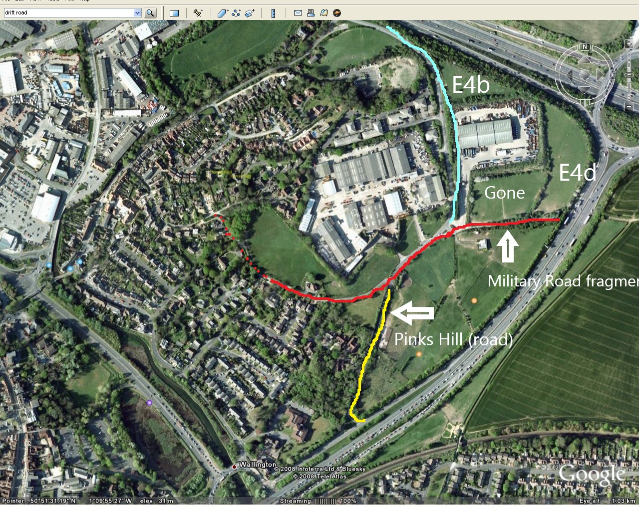
Aerial view showing Standard Way in blue, Military Road in red and Pinks Hill Road in yellow. The SUEZ Waste Transfer Station is between the two marked sites; the field adjoining and marked ‘Gone’ is a relatively new extension to the facility, ostensibly a maintenance area to service vehicles rather than, as previously, having to take them to Southampton.
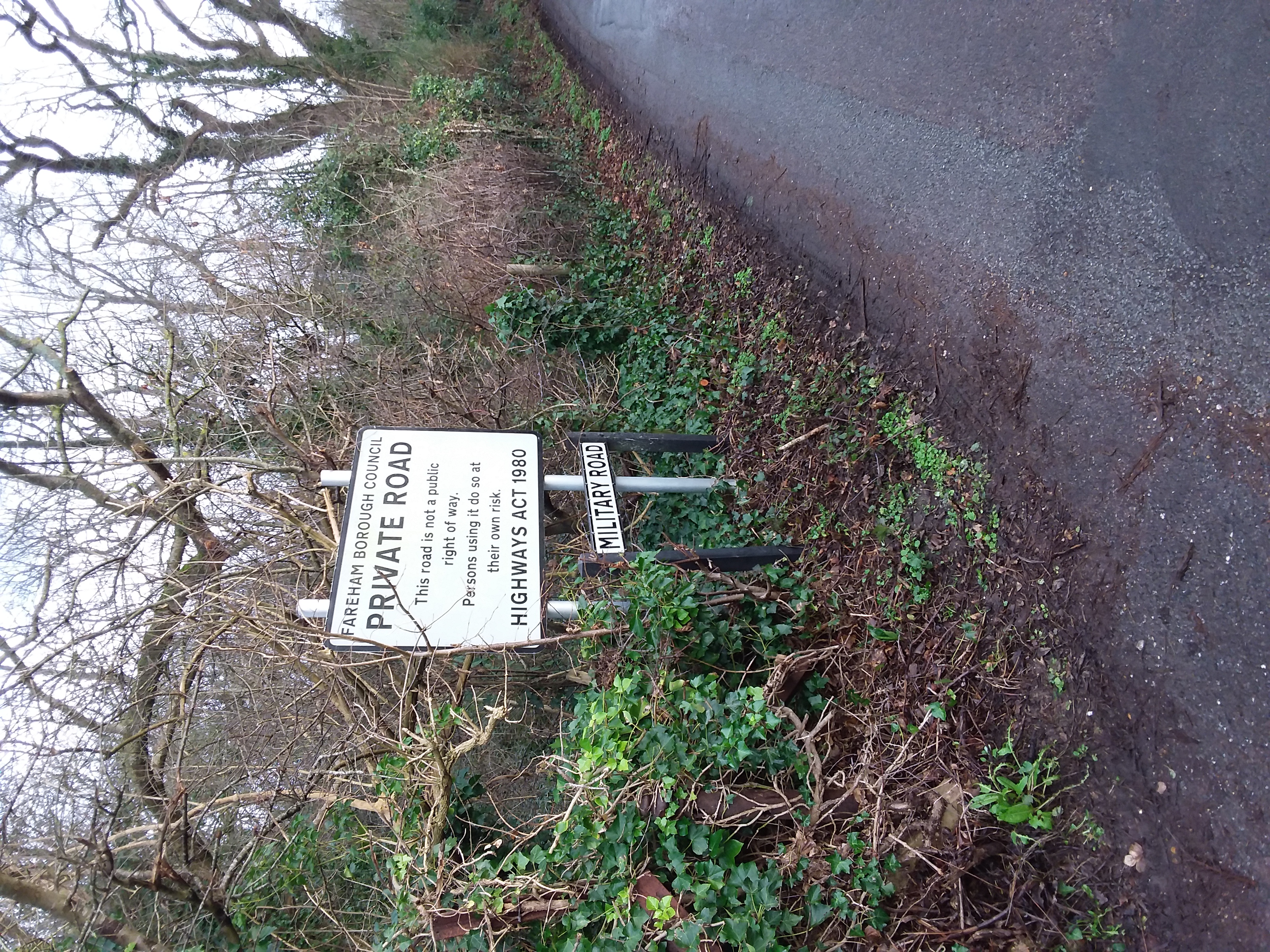
Photograph of Private Road sign.
Main points of initial submission:
Adverse indications for any development on these sites are that Standard Way is un-restricted and carries heavy lorries and other fast-moving Industrial Park/motorway-bound traffic. Access at both sites would be close to a tight, blind bend. Noise and airborne pollution levels would be unavoidably high, creating unpleasant working conditions. This is even more relevant now with the imminent arrival of two extra lanes on the M27. For practical reasons it brings into question whether the proposal can be considered ‘sound’.
We would argue whether either site can be considered ‘appropriate’ or described as being amongst the Existing Employment Areas. The listing by FBC is largely based on a perverse planning decision by Hampshire County Council allowing the (first) waste recycling facility to be erected there. Environmental degradation would be inevitable and the loss of green space in this area would have a disproportionate impact on the landscape and its wildlife.
Land at Standard Way is stated to be 2,000 sq m and Military Road 4,750 sq m. These are tiny amounts in comparison with quantified/prospective capacities at the sites at Daedalus, Solent 2 or Welborne (77,900 sq m, 23,500 sq m, and 76,140 sq m respectively). Also, with so many vacant industrial units available in the area generally it is hard to see that these proposals can be justified on a ‘needs’ basis.
There is reason to believe that the proposed access route to the Military Road site is problematical. Not only would it join Standard Way at a dangerous bend but the legality of using the truncated road, once part of the old MOD route to Portsdown Hill, may itself be in doubt even though it is owned by FBC. This might reasonably be considered a (possibly) insurmountable constraint.
Supplementary Hearing submission:
The accompanying document seeks to explain why WVCA contends that these allocated sites should not be listed ‘within Existing Employment Areas’ and should be removed. It also gives the background to the unusual designation of the most affected roads and the consequences for development pressure and traffic growth.
Relationship to Inspector’s Matters, Issues and Questions:
We believe that under Matter 8 Employment Need and Supply item 1 there is no proven justification for this scale of allocation. Also, under item 6 there is no proven need for extension to existing employment facilities given that there is no under supply locally – especially for warehouses (Item 5)
March 2022
................................................................................
Review and submission in respect of Local Plan 2037 (December 2021)
Hopes that we might have been spared some of the land grab predations endorsed by our Council in earlier versions of the Local Plan appear to have been premature. We had been aware that although housing allocations had been removed from the plan it would not stop any applications made by eager developers on their own initiative – and we voiced the misgiving as a warning against complacency in the Christmas 2020 edition.
Representations on the plan, which had to be made by 30 th July 2021, were constrained to three specific questions – whether the plan was legally compliant, whether it was sound and whether it complied with the duty to co-operate with neighbouring Councils (i.e. struggling to meet their own targets)
Employment sites:
Sadly, though the housing ‘endorsement’ was withdrawn from the plan (after the debacle now called Local Plan 2037) the two Employment allocations which had popped up (and were reported in that magazine) are now supported by FBC. These sites are described as North of Military Road, Wallington and Standard Way, Wallington. The FBC plan identifiers are E4b and E4d.
The Local Plan 2037 document describes its ‘Vision’ at Section 2.10 as:
‘New employment space will be located in the most appropriate locations that are attractive to the market and acceptable in terms of environment impact. Existing employment areas and zones will be supported, and all decisions made will seek a sustainable future for the employment provision in the Borough and its associated jobs.’
WVCA opinion is that it is difficult to see how either of these can be considered ‘appropriate’ as defined in these criteria. We would also take issue with the contention, expressed elsewhere, that these should be listed as being amongst ‘existing employment areas’. *
Major adverse indications for any development on these sites are that Standard Way is un-restricted nearby and carries heavy lorries and other fast-moving Industrial Park/motorway-bound traffic. Safety would be impossible to achieve since access at both sites would be close to tight, blind and dangerous bends. Noise and airborne pollution levels would be unavoidably high, creating unpleasant working conditions and be to the detriment of quality of life both for residents and tenants of nearby office buildings. This is even more relevant now with the imminent arrival of two extra lanes on the M27.
Land at Standard Way is stated to be 2,000 sq m and Military Road 4,750 sq m. These are tiny amounts in comparison with quantified/prospective capacities at the sites at Daedalus, Solent 2 or Welborne (77,900 sq m, 23,500 sq m, and 76,140 sq m respectively) and yet their environmental impact is huge for a village surrounded as it is by industry and where the loss represents the sacrifice of so few remaining areas of green space. With so many vacant industrial units available in the area generally it is hard to see that these proposals can even be justified on a ‘needs’ basis.
The excessive loss of green space here is about more than landscape impoverishment or an adverse impact on wildlife. In the process a unique setting, counterbalancing so much nearby industry is jeopardised and, as with all nearby threatened fields, valuable natural flood mitigation potential may be lost. Drainage and flood issues need to be taken particularly seriously here.
Downend – Wallington Gap
This refers to the expansion of the Downend Strategic Growth Area (SGA) (now referred to as West of Downend Road) with an associated new road proposed to access the Motorway approach road (A27).
While it is acknowledged that the land either side of the Motorway Approach Road (A27) is not a recognised Strategic Gap it has nevertheless always been valued as an important buffer zone on the eastern flank of the village. The land adjoining Pinks Hill Road was recently threatened and is still potentially at development risk. If the west of Downend Road scheme goes through a precedent is likely to be interpreted.
Given the findings of FBC’s own Landscape survey, even development on both sides of the Downend Road would cause character and appearance damage, especially on the western side of the road - which would intrude substantially into the lower slopes of Portsdown Hill. If development extended across the A27 as now likely the landscape quality would become non-existent.
All this would seem to be at odds with the Fareham Local Plan 2037 Vision at Section 2.10, which states inter alia that:
‘Fareham Borough will retain its identity, and the identity of individual settlements within the Borough, through measures that seek to retain the valued landscapes and settlement definition.
The natural, built and historic assets of the Borough will continue to be protected, alongside the Borough’s many valued open spaces, sports provision and leisure and community facilities. ‘
WVCA strongly supports the Council’s purported policy of retaining green spaces, protecting valued landscapes and wildlife, preserving district communities, and retaining buffers of green spaces. These aims cannot be achieved if the eastern flank of Wallington is developed alongside a new strategic growth area in Downend – joint development is incompatible with the notion of non-coalescence.
General points to do with traffic
On a general note, the revised plan purports to extend the mission towards environmental improvements and Section 9.98 about Air Quality and Section 11.41, also Policy D2: Ensuring Good Environmental Conditions elaborate on this. Thinking particularly about air quality, this is at odds with the likely outcome of yet more industry in Wallington and this possible new road junction on our eastern border.
Wallington is surrounded by fast and heavily loaded roads and there are probably more industrial premises within walking distance on several sides or in its centre (at Fort Wallington) than for any other residential area in the Borough. The road network includes the (soon to be 8-lanes) M27, a 6-lane approach road (A27) which might have a new junction on it to add congestion to the Delme Roundabout, and Wallington Way carrying an increasing burden of traffic to Broadcut, the feeder road to the Industrial Park. Noise and pollution are becoming a serious issue, especially for residents of Wallington Shore Road.
Summary
It is difficult to argue a technical point about whether the contentious items are ‘legally compliant’ or ‘compliant with the duty to co-operate’ (i.e. with neighbouring councils). But as to whether these proposals are ‘sound’ we would maintain that they are not and should be removed.
* The fact that they are so listed is likely to be as a result of a civil wrong committed some years ago when the (first) waste recycling facility was foisted on the site previously occupied by the MOD Victualling Depot. At the time there was widespread opposition, including by FBC, but HCC claimed that it was the only suitable location in the county!
OIAW December 2021
There is some great local news to lighten the bleak news of the pandemic.
As you will see from this Press Release on FBC’s Planning website, the Council has withdrawn all the proposed sites in Wallington (and some others) that they had identified for their Local Plan as possible sites for housing development. https://www.fareham.gov.uk/latest_news/pressrelease/pr_20200923_1
The Leader of The Council says that as a result of his intense lobbying of ministers and others and the number of houses required to be planned for in Fareham has been reduced, which permits the removal of these sites. The active support of local residents in submitting comments has without doubt played a key role but we should recognise that Cllr Woodward’s efforts have ensured the outcome that we wanted. I intend to write on WVCA’s behalf to thank the Leader, all the members and officers of FBC for their efforts to reduce the planned number of houses in Fareham and preserve the strategic gaps. We are very ready to lobby and criticise but we should give praise were it is due!!
In my view the last sentence of his quote is something about which we may need to continue to remind local decision makers:
"I am delighted that the intense lobbying that I undertook on behalf of the Borough with both ministers and civil servants has borne fruit in the Government's latest proposed method for calculating the requirement for new homes resulting in a very significant reduction in Fareham's requirements. Preserving our Strategic Gaps has always been a very high priority for me and for the Council and the proposed new Local Plan does just that. I hope it will be supported by our residents, many of whom are just as passionate about these issues.”
WALLINGTON VILLAGE COMMUNITY ASSOCIATION
OBSERVATIONS ON FAREHAM BOROUGH COUNCIL
LOCAL PLAN SUPPLEMENT 2020
The Wallington Village Community Association (WVCA) wish to reiterate its opposition to the identification of proposed development sites in Wallington in the draft local plan 2017 and the additional sites in the revised plan 2020 (supplement).
Whilst the Association recognises the obligation on FBC to cooperate and help neighbouring authorities, together with the Government’s National Planning Policy Framework, it is of the opinion that this is being done at the expense of Fareham’s residents and voters.
The Association strongly supports the Council’s identified policy of retaining green spaces, protecting valued landscapes and wildlife, preserving district communities and retaining buffers of green spaces. These aims cannot be achieved if the land identified in Wallington is developed, together with a new strategic growth area in Downend (to the east) and the Welborne Garden Village to the north. The same goes for other areas identified in the strategic plan as strategic growth areas or proposed areas for new allocations. The strategic gap around Stubbington is both designated as countryside (olive green) and strategic growth area (broken brown line).
If additional land for housing has to be identified, the WVCA believes that a small addition to the Welborne Garden Village would be more acceptable. Welborne is being promoted as an attractive garden village with green spaces whilst, at the same time, historic settlements such as Wallington, Portchester, Stubbington are faced with losing valuable green space.
The Association would also point out that the existing infrastructure is barely able to cope with the existing development as witnessed, for example, by the sewerage system in Wallington. The road network, health and education provision and local public services are stretched to breaking point.
For the above reasons the Association requests that the Council considers the above reservations in the next stage when it draws up its Publication Plan.
Submitted on behalf of Wallington Village Community Association
David F.B. Kett
Hon. Sec
Fareham Draft Local Plan deliberations have been restarted in the wake of the government's changes to the National Planning Policy Framework (NPPF) which were announced in July 2018 which increased the number of homes required in Fareham by 30%
The content below refers to the earlier analysis and comments
Consultative Phase
(update 27/11/17)
The process has moved on to the consultative phase and comments (using the FBC form) need to be received at the Civic Offices by Friday 8th December. Please take this opportunity of making your views known. WVCA assessment of the plan to date was as outlined in the second village bulletin which was issued at the end of last week.
Village Bulletin – Local Plan
(issued October 2017)
Background: Council Reviews of planning policies underpin development and land use and they take place about every ten or twenty years. Their purpose is to answer questions such as where new houses, community facilities and business areas should be built to cope with expected growth.
2017 Review: The latest review of Fareham Borough Council’s Local Plan was published in early October 2017 and the proposals earmark three areas in Wallington for housing – Land off Military Road (Gauntlett’s Field), land off Pinks Hill and land at the T-Junction of North Wallington and Standard Way (The Horses’ Field). Housing numbers allocated between them total 127. There is also a planned location for a business use site adjoining the Recycling Depot.
WVCA first response: There are valid arguments against development on these sites and we first listed them in our comments to the 2008 Site Allocation Review connected to the Local Development Framework exercise (LDF). As a first response the Association issued a bulletin to every house in the village alerting residents to the review and indicating that we intended to sustain opposition to development based on a variety of reasons including Coast and Countryside status (Green Belt), traffic and access considerations, visual intrusion and so on.
Arguments against development: As stated in the Bulletin we believe that the arguments against development on these sites which we put forward in 2008 are still sound but we must recognise that the landscape is changing both nationally and locally – and politically as well as physically. The clamour has grown, for example, about housing shortage and perceptions about difficulties in purchase and so on. Consequently some defences may be less sustainable than they were in the past. However it is also true that recent developments in the Borough coupled with a perception that official assurances on a limit to housing allocations now seem to be false may require FBC to justify their position more convincingly than in the past.
Consultative Phase: Now that the Plan has been published the process moves on to the consultative phase and this will last for six weeks, ending in mid-December. FBC will be holding a series of Exhibitions and Community Action Team (CAT) meetings during October and November to enable residents to find out more about the review. These aim to give an opportunity to find out about proposals for local areas and speak directly to planning officers and Councillors.
Our nearest Exhibition will be at Ferneham Hall on Wednesday 8 th November from 2-6 pm.
It is important to make your feelings known; we urge everyone to participate whenever given the opportunity. WVCA will continue to watch events very closely and prepare our case carefully. There will be more bulletins and briefing notes to help you with ‘thought-starters’ for letters of objection or comment as the matter progresses. If you are signed up to receive e-mails from the association you may also receive newsflashes by Mailchimp.