
Natural
The Water Meadow
 The land that we now call The Water Meadow is deemed very important to the village.
A pattern of care has been followed since the early days of Wallington Village Community – though the field has no doubt been cherished by generations of Wallington people before us. The land enables major social events like the Summer Fete and, day-by-day, it serves as a recreation space and a visual amenity.
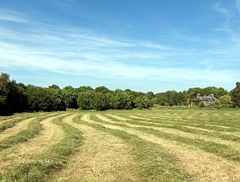
The Water Meadow has been a hay meadow for over a century and is managed by WVCA on behalf of the owners, a multi-national Insurance Company. Some 10 acres in area and bounded by the River Wallington to the south and mature plantations on the remaining sides, the meadow is an important wildlife habitat and is listed as a SINC (Site of interest for nature conservation). In recent years the meadow has been cut for hay in late June/early July by local farmers, the aim being to try and preserve one of the few remaining meadows that has never been subject to modern agro-chemicals or pesticides. (See Management Plan below)
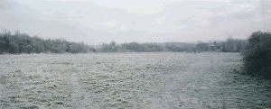
Officially designated as part of the Wallington Flood Plain, parts of the meadow routinely flood during the winter months and in this way, the meadow acts as traditional water meadow in dissipating some of the river’s energy during heavy rainfall.
If the land was to suffer development (as part of it did back in the 1970’s) then an historical link would also be lost, because the story of the field dates back centuries. In the Domesday Book the entry for Fareham records that the town was held by the Bishops of Winchester. From before that great inventory until well into the Middle Ages their power and influence was enormous. Great amounts of land were held in Southern England and our field probably got the (now disused) name of Bishops Mead, which appears on some maps, as a result.
 In England as a whole the wool and clothing trades grew steadily in importance from 1400 so that arable land gave way to sheep pasture. The sacrifice of arable land was only possible because following the Black Death in 1349 a reduced population required less of it. Around the year 1500 Water Meadows were a golden innovation and by 1630 they were fairly widespread in southern and western counties. By means of carefully constructed irrigation channels a meadow could be flooded in Winter and allowed to drain off the following March. Sheep would graze the young shoots until late April when they would be taken off to allow the grass to grow on to give one or more hay crops. The river brought nutrients more than water to the meadows and increased the yield of hay up to fourfold. In addition the winter temperature of the water was generally higher than that of the air and this in turn promoted growth.
Our water Meadows are now less than half the size that they used to be. They once to extended westwards at least as far as the Bridleway that (now) begins near Luckett’s Yard. For the first part a small stream ran alongside the path and past the front walls of the dwellings known as Clapgate Cottages. The cottages are now gone and the Fareham Industrial Park covers the fields that used to be, but the Clapgate stream still runs (just) – and that, too, was much bigger within living memory. It begins near Kneller Court at Funtley then passes Furze Hall Farm up on the Wickham Road. It is more than likely that the stream was used as a component of the Water Meadows system and it may also have been useful to the Tannery, which was sited near the junction of the two watercourses. The sunken lane near the Bridleway (now almost hidden) used to be called Watery Lane. The course the path may be close to the route of the old Roman road to Wickham.
Water Meadow Management Plan
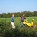 In 1987 the owners (Standard Life) agreed to a WVC initiative for the management of this natural asset. This involved tree planting at the Motorway end, removal of scrub on banks to aid stability, thinning of some tree species to encourage growth of others and a meadow cutting regime designed to help both wild flowers and summer amenity value. The plan was drawn up by the WVC in partnership with Fareham Borough Council and Greenspace, Hampshire County Council. (View Management Plan)
The River
Emergency Flood Plan
Flood Plan Summary
Built
Conservation Area

Part of the Conservation Area defined in 1979 - North End Cottages in North Wallington. Numbers 67,68 and 69 are Napoleonic and reputed to be old smugglers cottages, once having connecting doors. Numbers 71, 72 and 73 were built in the middle of the 19th Century while number 70 was built on the farm-track, which separated both terraces.
The road northwards to Spurlings Farm was closed to traffic when the M27 Motorway was constructed. It has been suggested that this was the old coaching road to Wickham and beyond; the presence of a former coaching inn near the Bridge (now a private house called Farriers Cottage) could support the belief.
Conservation Areas were first introduced by The Civic Amenities Act of 1967 for areas of special architectural or historical interest whose appearance it is desirable to preserve or enhance. There are no standard specifications – instead the local authorities consider all the factors that give an area its unique character.
In 1979, Fareham Today (the official journal of Fareham Borough Council) put great stress on the Council’s efforts at conservation within the Borough. High Street, Lower Quay, Titchfield haven and the Western Wards shoreline all featured prominently in the conservation plans but there was no mention made of Wallington, one of the oldest areas in Fareham. In the Autumn of that year the late John Perry (at the time both our Vice Chairman and that of Fareham Society) and Tony Munford (of Fareham Society and FBC) armed with maps delineated an area basically containing all of ‘Old Wallington’, including part of Wallington Shore Road, most of North Wallington, the Bridge and Wallington Brewery. It was felt that the more compact the area was the better the advantage to be gained from the designation of Conservation Area.
The Town Planning Committee approved it in December, and the precise definitions included Wallington Bridge within the southern boundary and following the course of the river northwards past the Council Depot to number 73 North Wallington. The eastern boundary is formed by the rear of numbers of 58 to 73 North Wallington and includes the former Wallington Brewery buildings. South of Drift Road the boundary contained vacant land to the rear of Clifton’s Yard but excluding post war properties fronting Radclyffe Road. The line continues southward along the footpath to include numbers 6 to 17 Wallington Shore Road, which forms the southern boundary.
Despite all the changes in Wallington in the 1960’s and early 1970’s, the area had retained much of its village atmosphere and it was hoped that the long overdue boost would be just the start of a brighter future for the village and one that would continue throughout the Eighties. It was an optimistic note on which to enter a new decade!
The 1980’s did bring many changes to the fabric of the village, both built and natural. They were signature years for the many ambitious plans that were to follow. Some of these did not mature until much later – for example the permanent Village Hall in 1995 and the Village Green and the erection of ‘period’ streetlights in spring 1996.

The view here, from autumn 1999, is of the ‘Village Green’ area leading onto the old bridge. The bridge is now in well-earned retirement from traffic. Fears about its structural soundness in later years caused some amusement to older villagers who remembered tanks and other heavy military hardware crossing it in the months leading up to D-Day!
Waterside Wall Conservation Project
In 2004/2005 Fareham Borough Council published a series of pen pictures of the Borough’s Conservation Areas. Wallington was number ten in the series and we were pleased to have the opportunity to comment on it during its final draft stages.
‘Wallington Conservation Area Character Assessment’ was published by Fareham Borough Council in May of 2007.
WVCA was happy to endorse the draft and its objectives but took the opportunity to try and raise awareness about some features of the village that although strictly outside the Conservation Area nevertheless contribute greatly to the character of the village. These ‘outliers’, we felt, were of sufficient importance to merit special attention if that could be achieved. One of these features is the old wall facing the river down from the Delme Roundabout. This old wall had formerly enclosed the grounds of Wallington House – where the new houses of Waterside Gardens and Pallant Gardens now stand.
An independent examination of the wall (Bursledon Brickworks) confirmed our belief that the wall was deteriorating significantly and that treatment was necessary to prevent the decay reaching a point where its structural integrity could be compromised.
An obvious indication of damage was the absence of a large number of capping bricks (about 175). Some of these had been stolen several years ago and when the risk was perceived the adjacent bricks that were loose (or had been loosened) were taken into safe keeping (estimated 75) by the affected householders.
The other major indication of damage was the presence of bricks whose faces were badly decayed. According to the consultants the cause was most likely to have been ad hoc re-pointing in the past using cement mortar rather than lime mortar. This had the effect, mainly, of creating mismatches in porosity so that moisture could be trapped within the bricks and the outer faces subsequently ‘blown’.
After discussion with the various owners of the properties backing on to it we signalled the intention to promote a restoration scheme. This would primarily be funded through our own Local Grants Initiative (qv) but we would also be seeking grant assistance from the Borough Council and would be looking for a contribution from the householders.
We approached Fareham Borough Council (Conservation Office) to see what possibilities existed for grant funding. In the normal course of events this would be through a so-called ‘Historic Building Grant’, however, to be eligible it would normally have to be a listed building or in a Conservation Area. The wall is neither, but we were able to make a convincing enough case for FBC to agree to accept an application from us. This was subsequently approved and £1400 pledged on completion of the work.
Our aim was to help to secure the future of the wall by some specialist maintenance e.g. re-pointing with exactly the correct lime mortar, replacement of coping bricks etc. Part of the general intention was to retain the character of the historic wall so that ‘unusual’ bricks would be kept if possible. Only if they were badly decayed or likely to affect surrounding parts of the wall would they be taken out and new facing bricks put in.
The overall objective was to stem the processes of decay whilst retaining the aesthetics of a structure that is so much a signature feature of the village - also to complete the task within sensible financial limits.
Although it has taken longer than expected we hope that everyone will agree that the finished result was worth the wait and that the objective has been achieved. The job has been completed within budget with the financial help of FBC, residents of Waterside Gardens and WVCA. Congratulations should go to Gary Saunders and Mark North for their painstaking restoration work.
It is our fortune that the wall survived - and better fortune that, in our times, the village grew a unifying body which now has the financial wherewithal to achieve visions unimaginable thirty years ago.
The wall is part of the heritage of the people of Wallington. We do not ‘own’ it any more than we ‘own’ Wallington Bridge but it is ours. It is part of our landscape and we would be the poorer if it were not there. We are lucky that we could prevent it falling down bit-by-bit and then saying after it was gone, ‘what a shame!’
Arthur Hackney
The accompanying pictures show the general state of the wall as it was and how it was starting to look towards the end of the project. Mark North puts in finishing touches. The work was completed by Christmas 2010.

The wall before...

...and after all the hard work...